Networked Urbanism
design thinking initiatives for a better urban life
apps awareness bahrain bike climate culture Death design digital donations economy education energy extreme Extreme climate funerals georeference GSD Harvard interaction Krystelle mapping market middle east mobility Network networkedurbanism nurra nurraempathy placemaking Public public space resources Responsivedesign social social market Space time time management ucjc visitor void waste water Ziyi

mapping
Visualizing different aspects of reality using georeferenced data available through various channels and geolocating user-generated inputs. Mapping makes reading the city at different scales with different layers and filters possible, and is also an intuitive and powerful channel for participation.
The project aims to enliven multiple elevational voids of the city of Muharraq, engaging various users who bring an array of programs over a continuously evolving spectrum of time.
As the city of Muharraq contains urban voids, the voids in plan also create elevational voids that expose blank wall facades. These blank facades, composed of brick or concrete walls, reflect sunlight to heat the city, especially with the current programmatic function as parking lots.
The project works with the juxtaposition of a light new scaffold structure against heavy existing solids. The public realm becomes an ongoing project that gets built up or down according to the user’s own needs. A set of users, all with different occupations, age group, and gender, can easily building up their own stall according to an ikea-like set of procedures. The accumulation of these stall-scaffolds can create an elevational market space, theater, or educational facility according to the user’s needs in different times of the year. Addressing the locale, the construction and deconstruction is part of the process of making the public space, the time and effort both an architectural construct. The narrowness of the scaffolds and the delicate textile skin are reminiscent of the old Meshirabyas, a balcony-type of finely detailed artifice. As its Arabic root of the word Meshirabya suggests “the place of drinking,” the project acts as a shade or screen with allows breeze to enter and create a cooled area for filtration and concoction of water as well as traditional beverages like Limonana, or Mint Lemonade.
These scaffolds bring life to the adjacent rooftops, creating a network of new public arena that continues the Arabic tradition of living in verticality. A newly established visual network will not only infill the elevational voids to reduce heating, but also activate the locale to create proximate destinations for people to sell, buy, or socialize. Each of these sites will respond with different programmatic functions over courses of years. Depending on their traditional character of the neighborhood, programs could range from a market in the Suq neighborhood to a space of worship and prayer near the Mosque. The multiplicity of program as a respondent to the locale of the place situates program on an underlying level of necessity. Program emerges from the needs of the users.
PROJECT STATEMENT
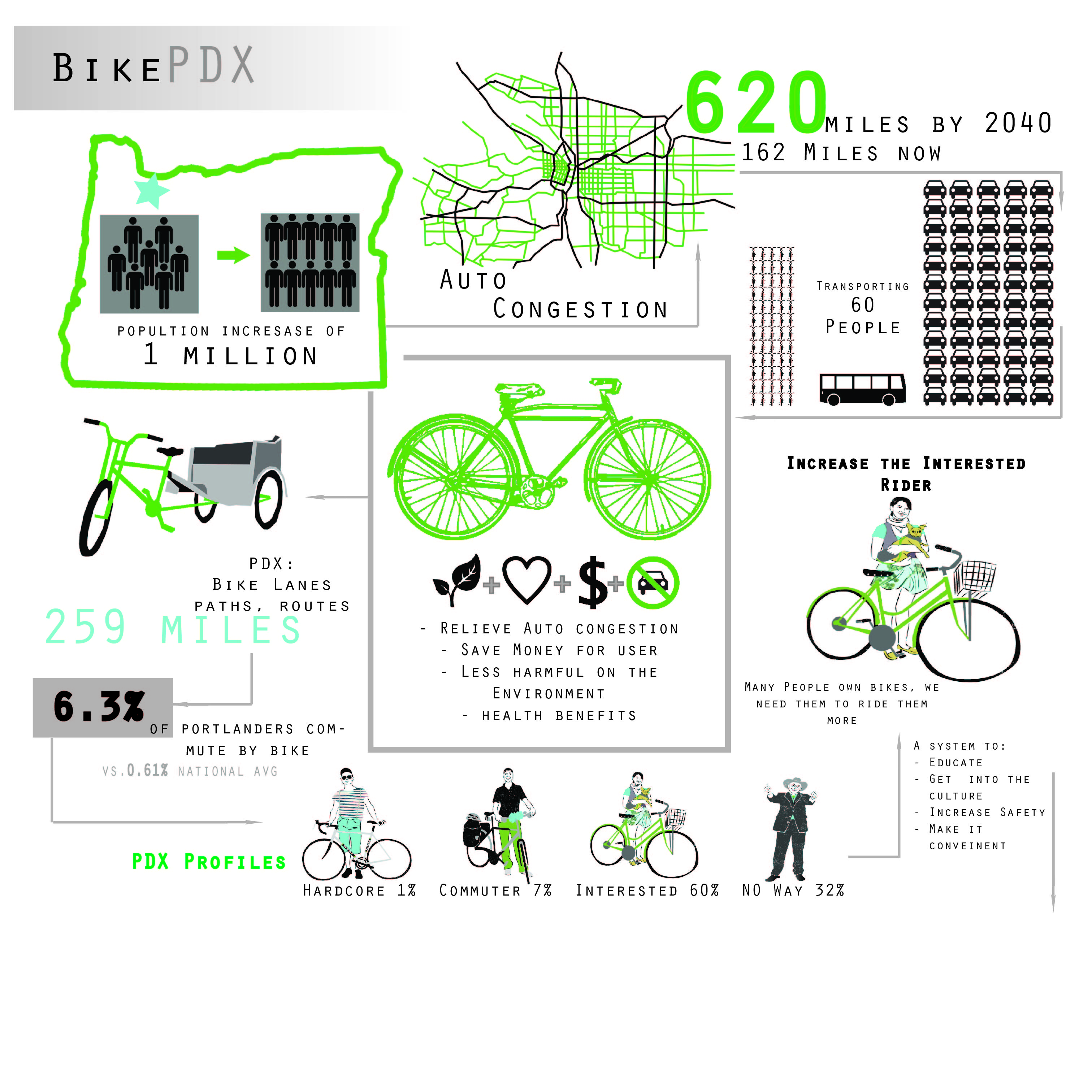
The problem is the future strain on Portland’s transportation infrastructure, due to the expected population growth of 1 million people by the year 2040.
Portland is expecting to become denser, and though Portland’s population has increased, the congestion of traffic has not. This is due to Portland’s predominant bike culture. Portland is America’s biking capital, with a bicycle commuter rate of 6.3% vs. the national average of 0.61%. There is already an existing system of bicycle pathways through the city of Portland, so building new infrastructure is not the way to generate more cyclists.
Our intent is to help Portland reach the modal split goal of 25% bicycle trips taken by the population inside the metro area. (more…)
We constructed a survey to better understand the people of Portland.

Here is the mock-up of the base structure/design of the interface of the App.

Here is video of our curated tour of density in Portland now and what is projected. We wanted to see where people thought two types of density (population and buildings) were both currently, and projected.
http://www.youtube.com/watch?v=X6ApWpOa2Wo&feature=youtu.be
Pixel is a web-based application that enables the public to explore the city in entirely new ways. Through the collection and mapping of real-time public sentiment, Pixel also generates a layer of information that can provide planners and policy-makers with profound insights into how people experience the city.

Pixel has been in development for several months, and the process has drawn on the input of numerous researchers and experts in a variety of fields at the intersection of design, technology, and urbanism. (more…)
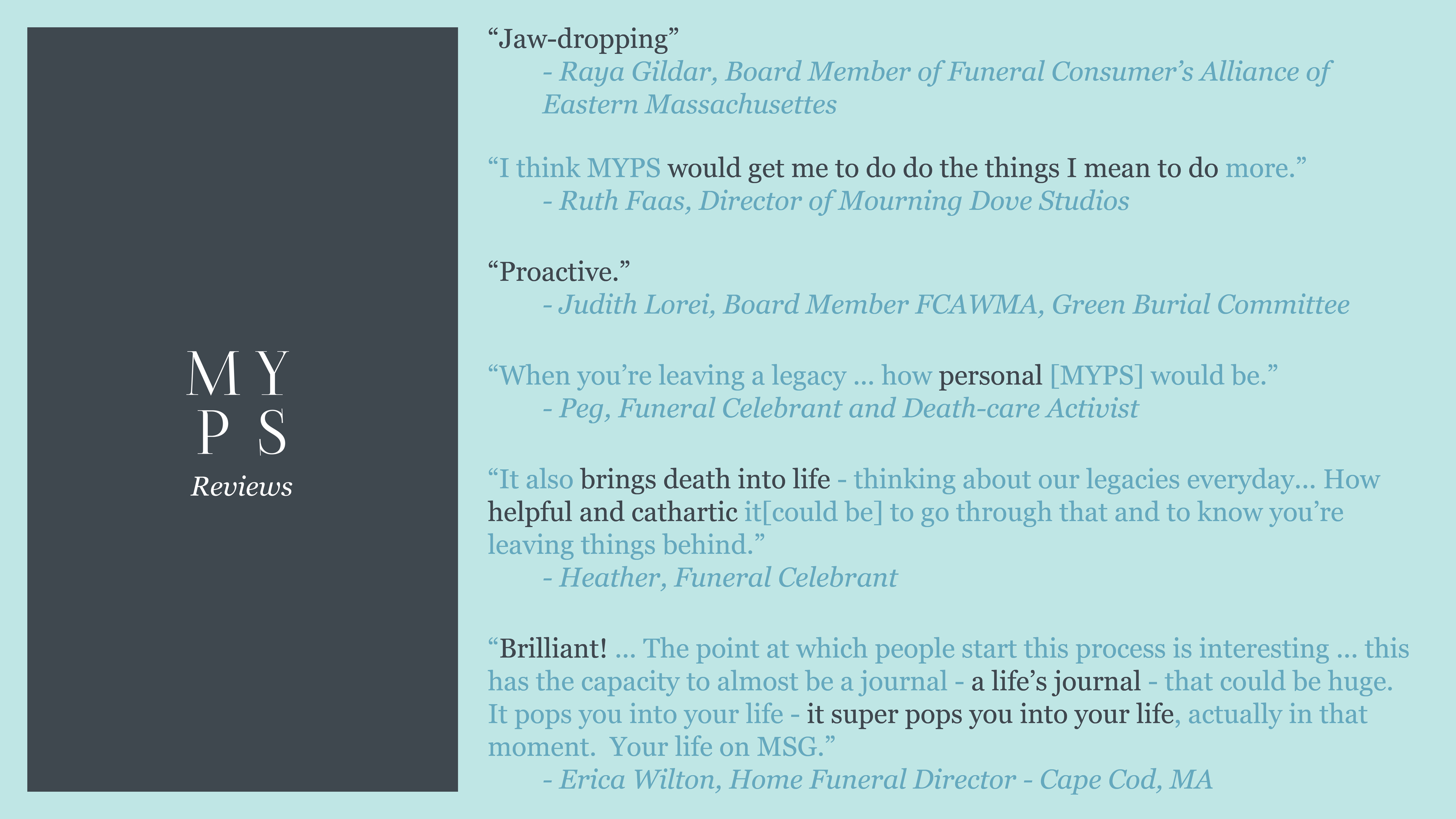
MYPS is personalized cloud to ground cartography that reshapes both how we compose our farewells and how we receive the farewells of others.
A P.S. is an afterthought – an easily appended message that crosses our mind after we think we have said all we mean to say. Yet the postscript also contains our final words, which are actually quite powerful. When combined with the power of place in the development of memories, these afterthoughts can create meaningful journeys for our loved ones to revisit after we are gone.
MYPS uses the GPS capabilities of mobile devices in combination with familiar media sharing formats to facilitate the process of recording our shared memories so our loved ones may literally revisit them after our passing.
The following video is a preview of my final review “experience”. It shows how MYPS could tie together three generations of memories. When my Mom came to see me in Boston, we visited the places my grandpa remembered from his own time living here during World War II. After her passing, I will be able to revisit our route to see the memories she left behind.
I was invited to participate in a networking event by Ruth Faas, my main contact in Boston’s death-care industry, on December 8th in Arlington, MA. Attendees included board members of both the Eastern and Western Massachusetts Funeral Consumer’s Alliances, Grief Therapists, Artists, Funeral Celebrants and Funeral Directors. Here’s what they had to say about MYPS…

Tuesday was game day. We took our idea to the ArchitectureBoston Expo first and to a working group at MIT thereafter. The feedback we received was more than helpful and certainly encouraging. We are excited to announce that the City of Philadelphia might be interested to pilot the project once we have a workable product.
Scott Liang | TJ McCourt | Benjamin Scheerbarth
This week is dedicated to collecting data to test our hypothesis (overlaying objective and subjective locational data might yield surprising and insightful junctures that can prompt targeted interventions and learning). For this, we are using Gund Hall, the main building of the Harvard Graduate School of Design, as laboratory.
Follow this link for the online part of the survey: https://docs.google.com/forms/d/1Hmga5pfhh6O-qWE6c0oSJbpWpZ56aS_2BRmbgfLuBMs/viewform
Scott Liang | TJ McCourt | Benjamin Scheerbarth
1 2 3 … 6 Next »