Networked Urbanism
design thinking initiatives for a better urban life
apps awareness bahrain bike climate culture Death design digital donations economy education energy extreme Extreme climate funerals georeference GSD Harvard interaction Krystelle mapping market middle east mobility Network networkedurbanism nurra nurraempathy placemaking Public public space resources Responsivedesign social social market Space time time management ucjc visitor void waste water Ziyi

digital
Working with the digital environment: the data, information and knowledge bits that flow over the Internet, and the interactions between them and the people. Looking into the connections and possible synergies between the digital and physical aspects of urban life.
![]()
Hear Here! is a platform that allows you to engage in virtual discussions with people within your vicinity. You can target an audience based on their location (be it your neighbors, concert goers, park patrons, building occupants, etc.) and engage in a rich exchange of information (ie. discussions, photo sharing, classifieds, comments, announcements, etc.). Hear Here aims to strengthen community by facilitating communication amongst other locals.
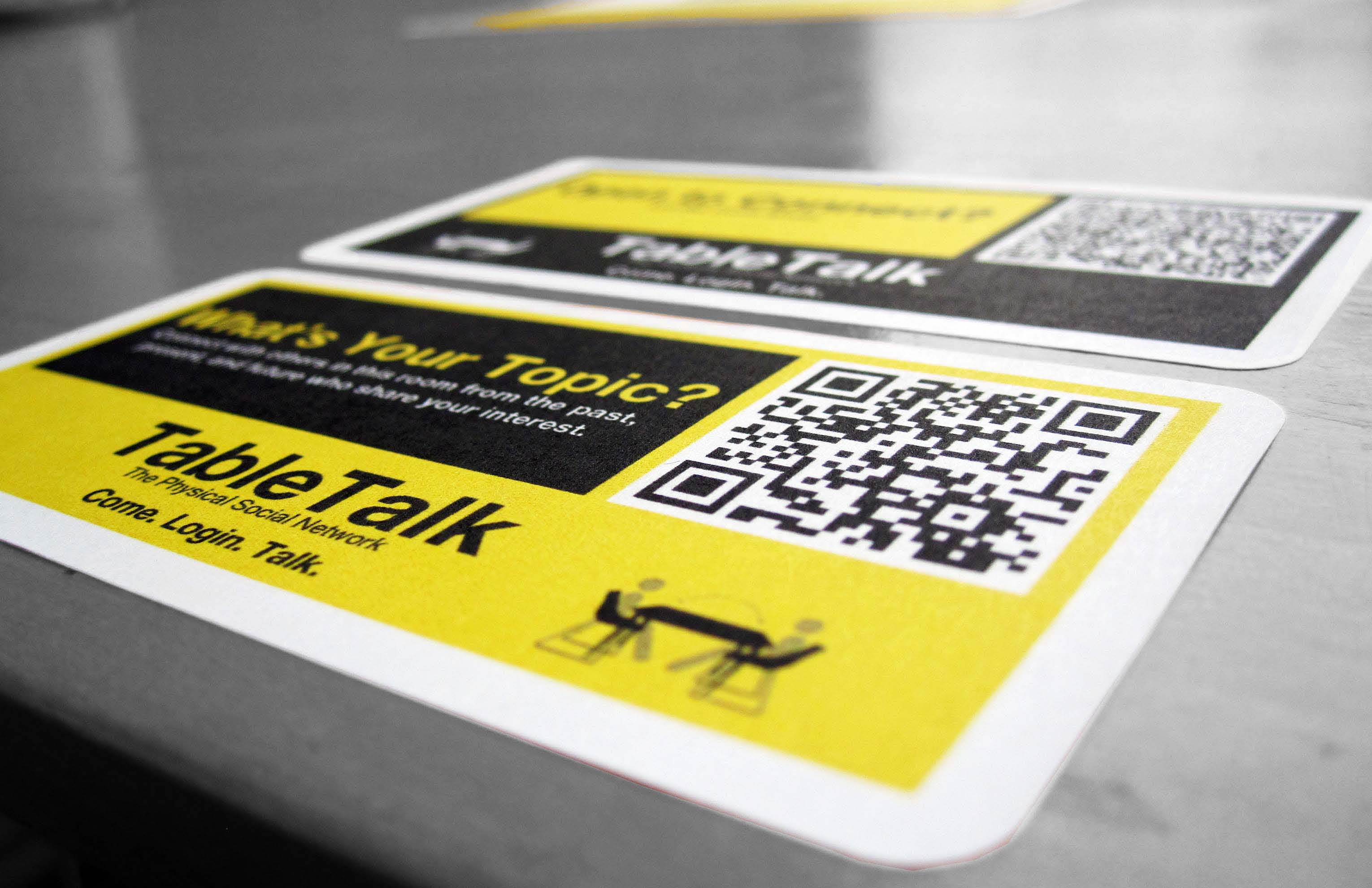
TableTalk is a physical social network connecting individuals of like interests by combining the physical and digital realms of urban space. This new community typology makes formerly invisible layers of shared interest visible in material space. By embedding personal metadata onto physical objects, a new community work space is developed connecting individuals in both real time and to past occupants; highlighting the importance of the city as place.
I am currently exploring the many ways this system can be implemented; including overlay onto existing program, embedding into objects, enhancing the social environment, and designing a new typology all together.

Bikenapped aims to raise awareness for bike thefts and empower cyclists to take action.
As Boston works towards becoming a world class bicycling city, promotion of cycling and cycling infrastructure has resulted in significantly rising ridership. However, this increase in cycling correlates with another phenomenon: the dramatic increase in bicycle thefts.
Bike theft is notoriously difficult to investigate, and stolen bicycles are equally difficult to recover. Theft victims often feel violated and helpless in the face of these crimes. There is nowhere for to speak out, no outlet for to take action. By gathering this community of individual voices, we can speak with a collective voice to shed light on the problem, and work together to find solutions.
MAPPING THEFT
One of the issues regarding bike theft lies in the shortage of data on these crimes. According to the reports from the Department of Justice, for every bike theft that is reported to the police, 4 or more thefts may have occurred. This severe underreporting prohibits us from seeing the full scope of the problem and from allocating adequate resources to tackle it. Bikenapped asks the community to participate in a user-generated mapping of theft incidents, to share information with our neighbors and our city.
TAKING ACTION
Raising awareness and disseminating information is crucial in addressing bike thefts. We seek to take the data beyond the digital realm and into the real urban environment we live in. Bikenapped asks users to post notice at the physical place of the theft to warn others of what had happened. The information is not just relevant on the internet, it is more relevant to all the people who use the spaces where these thefts happen.
CONNECTING VOICES
Change happens when we empower everyone to act. While bike theft is something most people experience alone, Bikenapped seeks to connect us with our neighbors and community. If we discover other people had their bikes stolen from the same place as ours, perhaps we can join together to demand for better safety measures in our neighborhood. If law enforcement is aware of certain zones of bike thefts, perhaps they are better equipped to police the area. If we know bikes have been stolen from a particular place, perhaps we will all be more vigilant to keep our neighborhoods safe from bike theft.
THINK BIG
How can I promote knowledge of space that is specific to actually being in the space? For the most part, we’re introduced to different spaces by someone who already has that knowledge. Originally I was trying to find a way to enable access and knowledge of space via social networking, apps, etc. through locally generated user content. However as the project has progressed, I’ve zeroed in the idea of “Boston” and its “spaces” as taught/shown by professional tour guides. Where do they get their information? Are their tours edited in any way by the corporate tour operators? Are they even from Boston? What do they think is missing from the tour? What if they had to give a tour to an audience of locals? Is authenticity of the experience/showing/teaching of Boston irrelevant?
Where is this going? I’m preoccupied with 2 questions: 1. Are visitors to Boston who do NOT desire the “knowledge of urban spaces” achieved by actually being there learning anything that is authentic or ideosyncratic about Boston specifically? Can you learn a city from the back of a duck boat? 2. The mirror to this would be; are visitors to Boston who use services like airbnb or yelp perhaps to have a more “authentic” experience of a city missing out as well? Regular local friends or tour guides aren’t going to take visitors to the “usual” spaces, but aren’t these spaces part of an “authentic” Boston experience too? Can you learn a city by ignoring its major, popular attractions?
START SMALL
There are at least 6 major tour operators in the city of Boston with maps and advertisements in major Back Bay hotels; the Marriot, the Westin and the Sheraton. On Sunday I visited the hotels and picked up every map and tour brochure available. (I was actually in the lobby of the Marriot when the Dalai llama arrived – thrilling!) The tours fall into mainly 3 categories; walking, on-off trolley loops where you’re encouraged to hop on and off the trolley and explore on your own, and motorized land-sea vehicle tours. There are other, more specialized tours where bikes or even Segways are used to get around.
I chatted with Deb, the desk representative for Old Towne Trolley tours and told her I was a local. Old Towne Trolley tours is actually a chain that operates in several cities. I asked Deb if she knew how Old Towne had plotted the route for their tour but she didn’t know. Interestingly an email I received back from Boston Duck Tours President and CEO Cindy Brown made the same claim. But I’ve been in contact with the founder of Cambridge Historical tours Daniel Berger-Jones and am trying to arrange and interview to specifically address this question. I’m also hoping he can connect me with more actual tour guides to interview.
I also visited the Boston Convention & Visitors Bureau unannounced & with no appointment but couldn’t get past the front desk. I did collect the names of a few people there who might be helpful with background information about how Boston is “marketed” to visitors.
As it was raining and I’m broke, I did not take a Duck Tour (30$ bucks!) nor did I visit Cheers. Yet.
I’ve established a few good connections and am following up with interviews this week.
GSD-Academic – Judith Grant Long Associate Professor of Urban Planning who studies the planning and effects of tourism on cities. Robert Pietrusko who will hopefully help me represent all this digitally/visually.
Corporate Tour Operators – Cindy Brown, President & CEO of Boston Duck Tours, Debi Jo Michael, Rick Steves’ Europe – Tour Operations & Planning,
Daniel Berger-Jones, Founder Cambridge Historical Tours
Background/Big Picture – Mike Healy, GSD Student and former tourism professional/tour guide, Pam Frechette, Visitor Marketing Manager Boston Convention & Visitors Bureau
I’ve also been down to Duck Tours twice and had some informal chats with tour guides and tour workers.
Next steps will be gathering expert info from my connections, mapping the tour routes and researching alternative stops, sights, spaces and developing my tour guide interview questions.
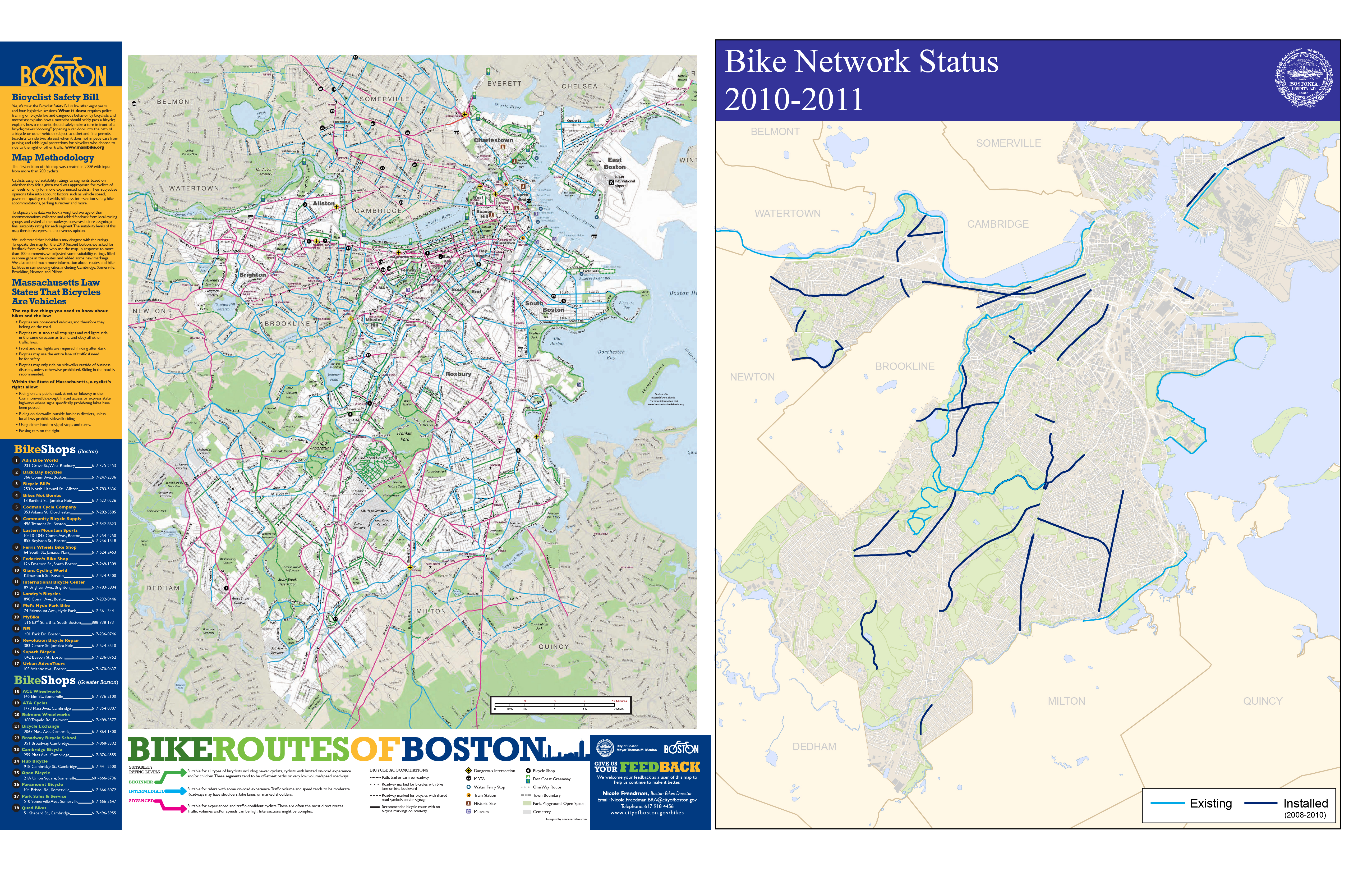
Riding a bike around the city of Boston you come to realize quite quickly that the cycle infrastructure is lacking. Even with the declaration by Mayor Menino that in Boston “the car is no longer king” and the cities recent focus on improving the cities cyclability, riding in the city is tough, scary and at times down right dangerous. The infrastructural improvements consist mostly of painted line bike lanes and Sharrows (painted bicycle arrows indicating an acceptable space within the lane a cyclist can occupy). While researching the current conditions I found that the mapping of the cycle infrastructure, and more the experience to be completely lacking. The maps of cycle lanes mainly consist of diagramatic overlays on plain google maps. I realized that there is not a map (at least I have not found one) that has the actual lanes drawn in. This type of mapping is deceiving to the rider as the system that exists is disjunct and rough with potholes and seamed pavement.
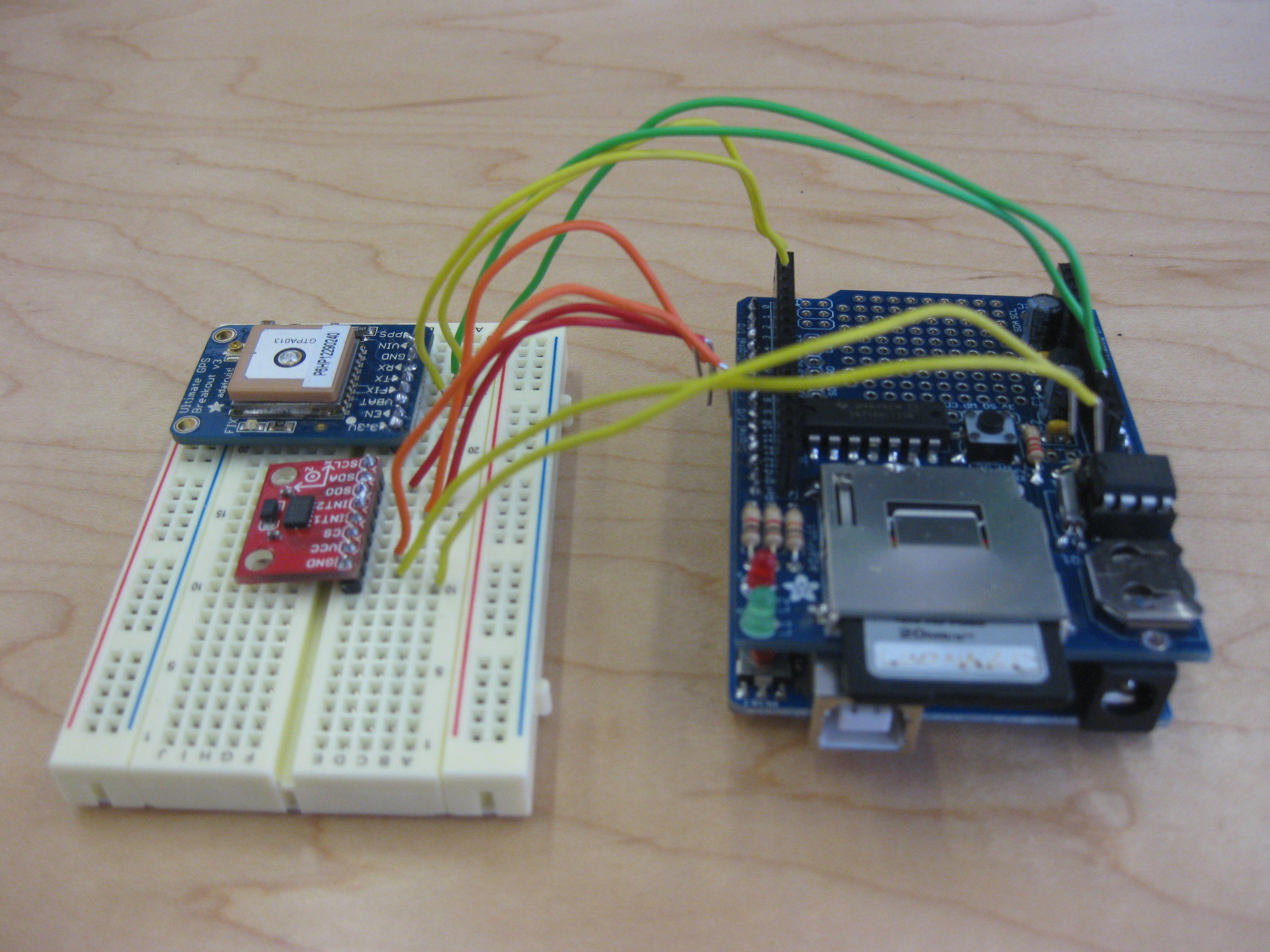
My goal first is to begin remapping the city of Boston’s cycle infrastructure to better map the experience of riding in the city. I am currently building a sensor consisting of a GPS and accelerometer to map the micro-topography in the city, additionally the speed, stops, turns and the side to side motion associated with pedaling hard will be used to redraw how open a street feels to the rider, the faster and smoother the ride, the wider the feeling of the street, the slower and more jerky the ride the narrower the feel.
From this I plan to develop an app that, though not as precise as the sensor I am constructing, has the opportunity to crowd source this data, as well as translate it back to the user, in essence creating real time crowd source mapping.
Where I Stand Now:
I am currently trying to convince all of the components of my sensor to start talking to each other. After about 15 hours yesterday I have come up with a new issue of the card not being read, hopefully that will be remedied shortly. Once that is done I just need to get the accelerometer into the party, we’ll see how that goes.
My hope for this project is that this new mapping will help to inform the urbanization and infrastructural improvements in the city.
I thought I was pretty much underway with my project, however after my desk crit last week it was suggested (gently) that I’m still circling, raptor-like. My original thought was to start collecting video of some lesser known space in Boston and work with the New Urban Mechanics and MyBlockNYC on a mapping project that might show more of the city through more eyes. I’ve also reached out to Ed Walker to talk about publicizing and reinvigorating spaces. I thought I might work with the group who approached Chris and Kate about a project on segregation. But I think I went too specific too fast.
THINK BIG: How do I get people in Boston out of their “space & place” comfort zones? How do I get them to different parts of the city without resorting to games & gimmicks?
START SMALL: I’m approaching this question from a new angle. I’ve reached out to a few non-Bostonians and asked them to create a tour of Boston based on anecdotal and web-based knowledge. I think I’m too ingrained in my own Boston experience to actually think like a tourist, or like someone who hasn’t been to Boston before and it’s giving me tunnel vision.
ACT NOW: This weekend, God help me, I’m going to go on at least one of the devised tours. For all my blustering about knowledge of space, there are more than a few spots I haven’t been in Boston for the sole reason that they’re tourist traps. I’ve never been to Cheers. Who knows? Cheers could be the most amazing place on the planet and I’ve been missing out all these years.
I would dearly love and cherish any thoughts on, and suggestions for, research and people who can help. Again, I’m stuck on this “knowledge of space” thing and I’m not sure where it’s going.
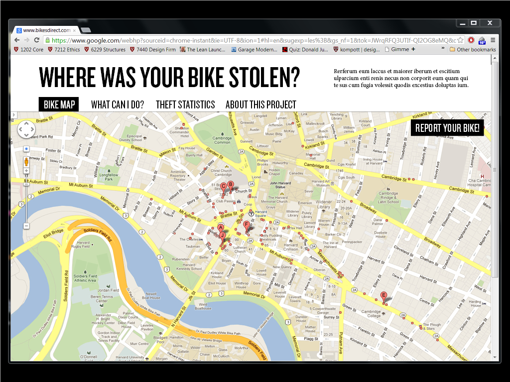
This week, I have been working on coding the bike theft map website. It is slowly coming into being. The basic layout and map functionality is completed, and the reporting mechanisms are minimally functional. I hope to complete this part of the project by this week.
In addition, I am scheduling interviews with bike theft victims to better understand the circumstances and explore other aspects of the crime that I have not yet explored. Particularly, I suspect there is a very personal narrative that exists with these events, and want to begin to collect those stories.
In the meantime, I am wondering how to reach out to bike theft victims to get the word out about the mapping tool, as well as collecting interviews. Do you know of anyone who has had their bike stolen? If so, please get in touch!
Think Big:
Design a physical social network in which people of similar interests, ideas, skills are connected through means of the physical environment.
Start Small:
There are currently two paths my research can take me; both of which I am excited about. I am currently pursuing both paths to see if they can soon combine into one.
1) A Physical Social Network in which a location specific object (ie. table within a cafe) is the point of connection between two people with similar interests. In this scenario, people can leave specific ‘traces’ of themselves throughout the city. You can sit at a table and see those who have sat there before you; based on individual layers. This concept begins to form new community boundaries and connections by means of our physical environment.
2) A digital submission process for New Urban Mechanics. I am currently working with the New Urban Mechanics office in developing a way to easily submit ideas, connect with those interested in similar concepts, and immediately connect someone needing a specific skill with someone who has it.
Act Now:
I am simultaneously working to conceptualize a platform for the physical social network while connecting with the New Urban Mechanics office and other companies who are attempting at connecting specific people based on interests, skills, or location. Current connections include:
- New Urban Mechanics
- OurCommonPlace.com at Harvard iLab
- USAdelante at Harvard iLab
- Active Pepper at Harvard iLab
- Ed Walker with Small Cities Movement
- Sociologist Bart Bonikowski
- Connections Group at Berkman Center for Internet & Society
Instead of the sticking ideas from the start, in this one week I am bombarded with opportunities (with brief description) to consider:
A.) Ephemeral City (location based app that focuses on nearby and occurring events. Can partner with iLab venture Hottspot http://hottspot.co/ [thanks Stacey] or work with @hyunez’s project to create something substantial together)
B.) OurGoods (work with existing Bartering community to add a layer of physical socializing)
https://ourgoods.org/users/4827/profile
C.) Turf in the Plaza (Ad hoc artificial turf in wide-open plazas to redefine spatial quality. Best to work with New Urban Mechanics.)
D.) PING in the real world. (Projection installation that makes people play Ping in real life.)
http://www.creativeapplications.net/games/ping-augmented-pixel-tutorials-games/
E.) Student p2p support. (Working with HBS startup USAdelante to create Mobile App that bridges students to support each other, as a solution to the overly high ration between students and counselor)
Act Now :
What I must do now is make a choice. I believe I know what the next steps would be for each of the paths.
Think Big:
I want to help Boston support and promote hyper-local knowledge of space to improve racially/ethnically segregated and economically stratified socio-spatial interaction/habitation. In other words, how can cities use digital crowdsourcing and geosocial networking to make more city spaces visible to more people?
Start Small:
MyBlockNYC.com is an interactive mapping website that captures and presents personal video accounts of the life and culture of New York City with the goal of creating an intimate, evolving, and complete portrait of the city. New Yorkers upload videos they take of their neighborhood which are then geo-tagged and organized geographically, thus building an interactive video map of New York. I’ve contacted the developers of myblockNYC.com about their site and what it would take to expand the tool to Boston. I’ve also contacted Boston Mayor Menino’s New Urban Mechanics lab and asked for the contact information of the group working on segregation that was mentioned in our studio’s meeting last Thursday.
Act Now:
While I’m waiting to hear back from the New Urban Mechanics lab, this weekend I plan to start taking my own video of some of the neighborhoods identified as relatively homogenous via 2010 census data.
« Previous 1 2 3 4 5 Next »