Networked Urbanism
design thinking initiatives for a better urban life
apps awareness bahrain bike climate culture Death design digital donations economy education energy extreme Extreme climate funerals georeference GSD Harvard interaction Krystelle mapping market middle east mobility Network networkedurbanism nurra nurraempathy placemaking Public public space resources Responsivedesign social social market Space time time management ucjc visitor void waste water Ziyi
bike
All you need to know about bikes in the city.
Think Big
As Boston continues on its mission to make the city into “a world-class bicycling city by creating safe and inviting conditions for all residents and visitors,” ridership and interest in cycling have all been on the rise. With new bike lanes, a new bike share program, and new cycling events coming to the city, we see a concerted effort to promote bicycling in Boston. However, with the rise cycling, we also see a rising trend in bike thefts as well. While ridership from 2007-2009 increased by 122%, bike thefts in Cambridge alone has gone up 54% from 2009-2010.
The issue of bike thefts is already a persistent problem in cities with robust biking culture such as London, where over 20,000 bikes were reported stolen in 2010 alone. Not only are the crimes detrimental to cycling culture in a direct way, but they also produce a type of psychological trauma. Studies have shown that 1 in 4 people who have had their bicycles stolen, never ride again.
Bike thefts as a phenomenon is complex and must be studied from all aspects, examining the different roles that factor into the narrative. From the bike owner’s perspective, we look at issues of bike security practices and theft deterrence and awareness. From the thief perspective, we must understand the risks they take and how they operate. Bike theft as crime is low priority for most police forces. Even when apprehended persecution is minimum, making bike theft a low risk/high reward crime. Finally, the aftermarket for stolen bikes should be examined. Prospective used-bike buyers create the market for stolen bikes. How are used/stolen bikes sold, and how can buyers be a part of the effort to reduce theft?
Start Small
The first stage of the project calls for data collection and research. I am in the process of building a website that will allow users to geotag where their bikes were stolen. We can begin to get a “heat-map” of high(er) theft areas, and begin to analyze their commonalities. Data will be user submitted. The website will both function as a research tool, and also as information for the general public and part of a possible recovery effort.
Act Now
Interviews with the Harvard Police Department will be conducted on understanding the criminal charges and the punishment for bike thieves, how the police combats this rising problem, current initiatives, as well as a request for crime statistics and possible police reports.
Understanding the negative impact that Google Maps has had on the realm of cartography, expressing the map as either a flat diagram or 3d satellite imaging, I am looking to understand how crowd sourcing can help to remap our understanding of the city. Many urbanites carry super computers in their pockets, full of sensors and transmitters these devices have the power to collect and disseminate information in real-time.
Focusing on the growing use of the bicycle as a main means of transportation I will begin remapping the city in an effort to describe the experience of riding in the urban environment. My hope is that this research will not only map the existing conditions, but also inform future urban developments.
I am currently researching what the City of Boston has already done, and is doing to improve the cycle infrastructure. I am interviewing people from Boston Bikes, Boston Cyclists Union and Livable Streets in order to gain a comprehensive understanding of the current conditions. I am also constructing a sensor that will be mounted on my bike that will link accelerometer data with GPS coordinates to map the micro-topography of the city, this is the first step in developing an app that will use smart-phones to collect this data and continuously remap the city in real-time.
01leonard, 02share, 03experience mapping, 04crowdsource
MIT automatic real-time mapping project is really blowing my mind right now.
The following data was logged during the studio bike ride on Tuesday with the iphone app, MapMyRun. The data is more interesting than I originally thought since the pace was measured in realtime, and not as an average at the end. You can see the variable pace graphed along with the elevational data, which gives us a better understanding of the route. Rather than the trip takes us 50 min to complete, we know where we were the slowest, and can better identify the conditions that effect bike traffic (ie: road conditions, car traffic, multiple crosswalks etc.)
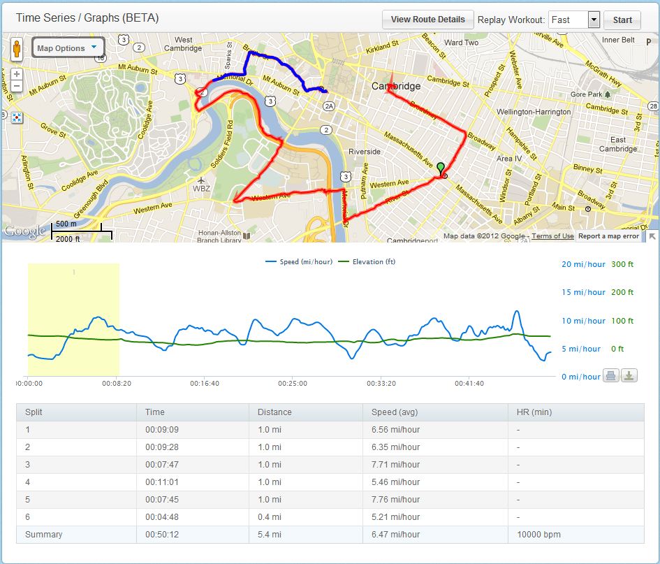
What is my map telling me?
Just found this really cool stop motion animation. The whole thing is done using Google Maps Street view.
The ambition of this project responds to the context of apathy, detachment, and alienation individuals experience in response to challenges they face in urban environments. The project specifically focuses on air quality and the opportunities that sensor technology, low-cost do-it-yourself electronics, and social media enable individuals to explore, understand, and discuss within their communities. The current infrastructure of air-quality monitoring devices within Boston provides a misleading portrait of air quality. While the air quality can be considered “good” on average, an understanding of the micro-environments we experience on a daily basis aren’t adequately understood. This project provides the tools to explore these problem areas and serves as a template to imagine how individuals and communities can actively engage the public realm.
![]()
Research methods and project approaches are developed in two forms. The first is concerned with creating the processes and spaces necessary to enable participation and engagement. While citizen science efforts have a mixed history, this work is less about collecting legitimate data than it is about empowering individuals with the tools necessary to not only collect data, but also understand the different ways that data can be collected and transmitted. Empowerment cannot be considered authentic unless the individual has the capacity to decide how and if information is communicated and to whom. The second form of this work is about creating the tools necessary to enable the measurement of air quality. These tools are built upon a conceptualized kit of open-source and readily available set of parts which can be expanded upon to produce a variety of configurations. In a sense this D.I.Y kit is intended to be flexible as to allow for personal reconfiguration as well as function in a variety of opportunistic contexts. (more…)
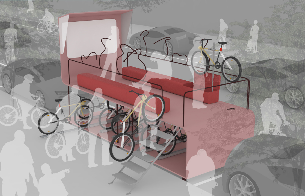
I worked on the concept of urban bike station for bikers. I began the project with the interest in bikes and the growing culture. When I first noticed that bikes are often locked on street signs and trees, I thought about the relationship of bicycles and urban space.
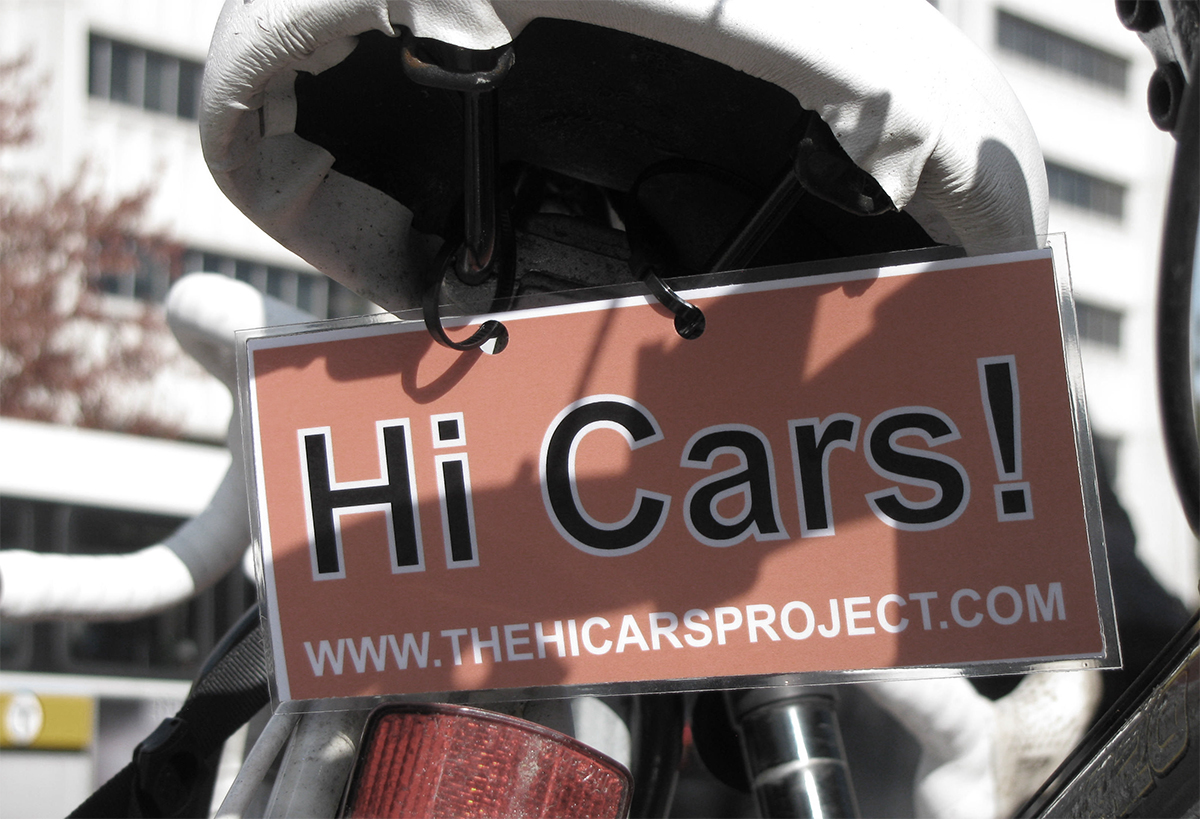
The Hi Cars! Project is an attempt to change the tenor of how cars and bikes interact on the streets of Boston-by focusing on the people in them. We know that saying hi won’t solve all of our problems with sharing the road and that we also have to work for better infrastructure, better enforcement, and better safety education for drivers and cyclists, but we also know there is something powerful in the attitude adjustment that comes with taking a more playful, conversational approach.
« Previous 1 2