Networked Urbanism
design thinking initiatives for a better urban life
apps awareness bahrain bike climate culture Death design digital donations economy education energy extreme Extreme climate funerals georeference GSD Harvard interaction Krystelle mapping market middle east mobility Network networkedurbanism nurra nurraempathy placemaking Public public space resources Responsivedesign social social market Space time time management ucjc visitor void waste water Ziyi

GSD Harvard – Fall 2012
Master Studio carried on during the Fall semester at the Urban Planning and Design Department at Harvard Graduate School of Design (GSD). Exploring the new role of the urban designer as an activator, mediator and curator of social processes in a networked reality where citizens are active producers or prosumers.

Bikenapped aims to raise awareness for bike thefts and empower cyclists to take action.
As Boston works towards becoming a world class bicycling city, promotion of cycling and cycling infrastructure has resulted in significantly rising ridership. However, this increase in cycling correlates with another phenomenon: the dramatic increase in bicycle thefts.
Bike theft is notoriously difficult to investigate, and stolen bicycles are equally difficult to recover. Theft victims often feel violated and helpless in the face of these crimes. There is nowhere for to speak out, no outlet for to take action. By gathering this community of individual voices, we can speak with a collective voice to shed light on the problem, and work together to find solutions.
MAPPING THEFT
One of the issues regarding bike theft lies in the shortage of data on these crimes. According to the reports from the Department of Justice, for every bike theft that is reported to the police, 4 or more thefts may have occurred. This severe underreporting prohibits us from seeing the full scope of the problem and from allocating adequate resources to tackle it. Bikenapped asks the community to participate in a user-generated mapping of theft incidents, to share information with our neighbors and our city.
TAKING ACTION
Raising awareness and disseminating information is crucial in addressing bike thefts. We seek to take the data beyond the digital realm and into the real urban environment we live in. Bikenapped asks users to post notice at the physical place of the theft to warn others of what had happened. The information is not just relevant on the internet, it is more relevant to all the people who use the spaces where these thefts happen.
CONNECTING VOICES
Change happens when we empower everyone to act. While bike theft is something most people experience alone, Bikenapped seeks to connect us with our neighbors and community. If we discover other people had their bikes stolen from the same place as ours, perhaps we can join together to demand for better safety measures in our neighborhood. If law enforcement is aware of certain zones of bike thefts, perhaps they are better equipped to police the area. If we know bikes have been stolen from a particular place, perhaps we will all be more vigilant to keep our neighborhoods safe from bike theft.
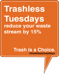
The average American throws away 4.5 lbs of trash every day. Added together, that’s the same weight as 2.3 million Boeing 747 jets every year just in the U.S. Trash disposal has been proven to be harmful to environment, costs billions of dollars in taxes, and disproportionately impacts poor communities surrounding landfills and incenerators.
Trashless Tuesdays is a public awareness and public commitment campaign that aims to reduce the amount of waste going into our landfills and, through incenerators, into our atmosphere. If every American committed to produce zero trash just one day a week that would mean over 50 BILLION pounds of trash diverted from landfills each year. And the added benefit is that once people start paying attention to their waste stream even just once a week, research shows that they will continue to pay attention and change their consumption and waste disposal choices the rest of the week as well.
So here’s how it works:
1. Go to http://www.ipetitions.com/petition/trashlesstuesdays/ to sign the Trashless Tuesdays petition as a sign of your public commitment and to see which of your friends, neighbors, countrymen are also signing.
2. Starting this coming Tuesday, eliminate all trash from your day. You can compost. You can recycle. But avoid the landfill.
3. Some helpful hints: think ahead, bring your lunch, use non-disposable coffee mugs, water bottles, plates, and utensils, use cloth towels instead of paper towels, and pay attention whenever you buy a food or product to whether the packaging is destined for the landfill.
4. Document your experience, tell your friends, and join the conversation on Facebook and Twitter (#trashlesstuesdays).
5. Have fun with it.
THINK BIG:
WeShare is a public service platform committed to promote equity and access in the application for college and university led community programs. WeShare serve applicants and member programs by promoting holistic application and selection process.
START SMALL:
Membership is open to college and university led non-profit programs that strive for provide vital resources to local communities and grow public service leaders on multiple levels in the Boston and Cambridge communities.
On WeShare, applicants discover amazing community-based, nonprofit public service programs they would have never otherwise known. WeShare also believes strongly in providing free and equal access to non-profit programs for all applicants, regardless of socio-economic status.
For non-profit programs:
+ Many programs are small scale and cannot afford to have a website. WeShare can provide easy setup for them to have a storefront. Better publicize themselves with statements, images, videos and contact information.
For applicants:
+Applicants who want to explore can search for programs based on Interest, community, day, type, time period, etc.
ACT NOW:
I’m trying to connect to as many programs as I can. Also there are several key projects that I’m participating to establish better connection with them. Meanwhile, I’m revising the website interface to make it more appealing and functional for applicants and member programs.

THINK BIG
How can I promote knowledge of space that is specific to actually being in the space? For the most part, we’re introduced to different spaces by someone who already has that knowledge. Originally I was trying to find a way to enable access and knowledge of space via social networking, apps, etc. through locally generated user content. However as the project has progressed, I’ve zeroed in the idea of “Boston” and its “spaces” as taught/shown by professional tour guides. Where do they get their information? Are their tours edited in any way by the corporate tour operators? Are they even from Boston? What do they think is missing from the tour? What if they had to give a tour to an audience of locals? Is authenticity of the experience/showing/teaching of Boston irrelevant?
Where is this going? I’m preoccupied with 2 questions: 1. Are visitors to Boston who do NOT desire the “knowledge of urban spaces” achieved by actually being there learning anything that is authentic or ideosyncratic about Boston specifically? Can you learn a city from the back of a duck boat? 2. The mirror to this would be; are visitors to Boston who use services like airbnb or yelp perhaps to have a more “authentic” experience of a city missing out as well? Regular local friends or tour guides aren’t going to take visitors to the “usual” spaces, but aren’t these spaces part of an “authentic” Boston experience too? Can you learn a city by ignoring its major, popular attractions?
START SMALL
There are at least 6 major tour operators in the city of Boston with maps and advertisements in major Back Bay hotels; the Marriot, the Westin and the Sheraton. On Sunday I visited the hotels and picked up every map and tour brochure available. (I was actually in the lobby of the Marriot when the Dalai llama arrived – thrilling!) The tours fall into mainly 3 categories; walking, on-off trolley loops where you’re encouraged to hop on and off the trolley and explore on your own, and motorized land-sea vehicle tours. There are other, more specialized tours where bikes or even Segways are used to get around.
I chatted with Deb, the desk representative for Old Towne Trolley tours and told her I was a local. Old Towne Trolley tours is actually a chain that operates in several cities. I asked Deb if she knew how Old Towne had plotted the route for their tour but she didn’t know. Interestingly an email I received back from Boston Duck Tours President and CEO Cindy Brown made the same claim. But I’ve been in contact with the founder of Cambridge Historical tours Daniel Berger-Jones and am trying to arrange and interview to specifically address this question. I’m also hoping he can connect me with more actual tour guides to interview.
I also visited the Boston Convention & Visitors Bureau unannounced & with no appointment but couldn’t get past the front desk. I did collect the names of a few people there who might be helpful with background information about how Boston is “marketed” to visitors.
As it was raining and I’m broke, I did not take a Duck Tour (30$ bucks!) nor did I visit Cheers. Yet.
I’ve established a few good connections and am following up with interviews this week.
GSD-Academic – Judith Grant Long Associate Professor of Urban Planning who studies the planning and effects of tourism on cities. Robert Pietrusko who will hopefully help me represent all this digitally/visually.
Corporate Tour Operators – Cindy Brown, President & CEO of Boston Duck Tours, Debi Jo Michael, Rick Steves’ Europe – Tour Operations & Planning,
Daniel Berger-Jones, Founder Cambridge Historical Tours
Background/Big Picture – Mike Healy, GSD Student and former tourism professional/tour guide, Pam Frechette, Visitor Marketing Manager Boston Convention & Visitors Bureau
I’ve also been down to Duck Tours twice and had some informal chats with tour guides and tour workers.
Next steps will be gathering expert info from my connections, mapping the tour routes and researching alternative stops, sights, spaces and developing my tour guide interview questions.
Unfortunately, I’ve spent the last week out of the country so progress has been slow. However, I’ve managed to narrow down my research interest toward exploring ways to visualize and understand urban energy flows in and around Boston. At my desk-crit before I left, we discussed possibly creating a video or other type of visualization as part of an educational curriculum about energy conservation. Since the first step toward attacking an issue such as energy conservation is understanding the problem, I think a type of “Public Service Announcement” that makes people aware of how energy is distributed throughout Boston is a good start.
Toward this end, I’ve managed to arrange a couple of meetings this week with the office of sustainability at Harvard to get a grasp on how the university’s grid interfaces with NSTAR and other regional energy providers. They may also have some good ideas about how to kick-start initiatives aimed at conservation in an educational setting. I’d also like to talk to people at the School of Education at Harvard, and at some public schools in the area (one of my professors suggested I contact the people at the Cambridge mayor’s office for this) about what initiatives exist in terms of sustainability in the classroom.
On a somewhat related note, this was a quick concept collage that I came up with before I took off – the idea would be that kids could participate compete in program to monitor their energy use at home as part of a more comprehensive curriculum. I haven’t totally abandoned this idea, and I think I could roll it in with my other ideas to create a more holistic approach to this idea of understanding urban energy flows.
Think Big
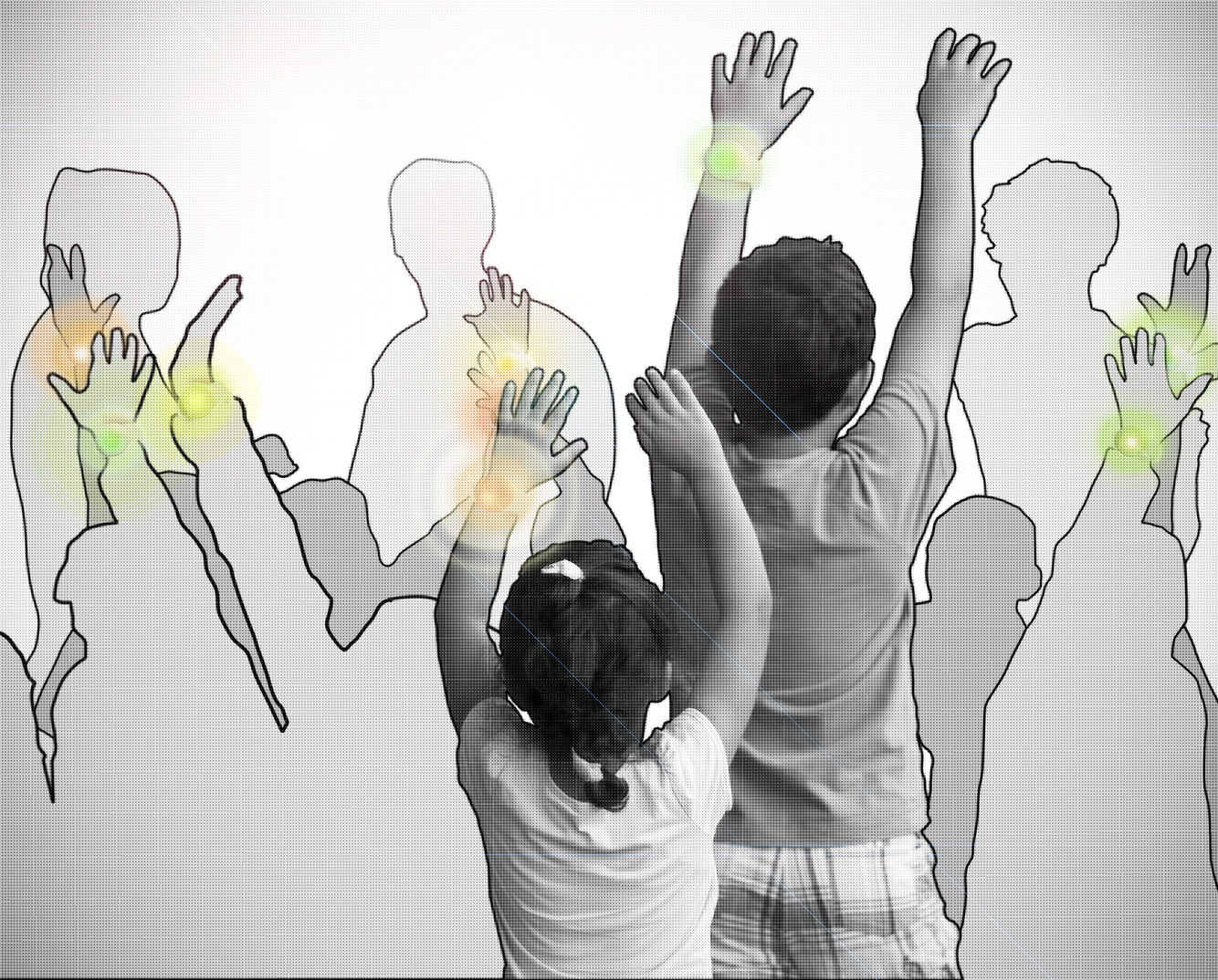
With little extra funding to reinvigorate public spaces in cities today, new strategies and tactics need to be developed to improve our public spaces so they better serve residents, engage community, and foster interactions. While the development of these strategies and tactics may involve high-level collaborations between many different stakeholders in the community, new ideas/methods/strategies for activating public spaces can also be developed “on the fly” by individuals taking action in the public spaces and making connections between stakeholders and organizations as they go. My goal for this studio is to become one of these individuals and hope to gradually develop larger strategies for activating public spaces and promoting stakeholder collaborations based my experiences this term.
Start Small
I decided to use the Cambridge Common as the public space to focus my efforts on this term. I spent a lot of time the last weekend observing the park and how people use it. I then brainstormed a lot of different ideas for activities and art projects that would serve different users of the park, but the feedback from our “sharing” session on Tuesday encouraged me to develop a particular goal to work towards. After meeting with staff at the Cambridge Historical Society yesterday, I developed a specific goal and brainstormed different interventions to try to meet that goal. My goal is: Capture the essence of childhood in people of all ages in the Cambridge Common.
Act Now
To try to spark the imagination, wonder, and curiosity that are essential to childhood, I’ve brainstormed a few different ideas for interventions. I’m going to start with some intervention prototypes this weekend in the Common on the small scale and see how they go, to then reassess the ideas, successes/failures/opportunities/problems and further develop the prototypes.
Past/Current/Near Future Connections include: New Urban Mechanics Lab, Cambridge Historical Society, Cambridge Art Council, Cambridge Historical Society, LZ Nunn, Ed Walker, Jim Lasko.
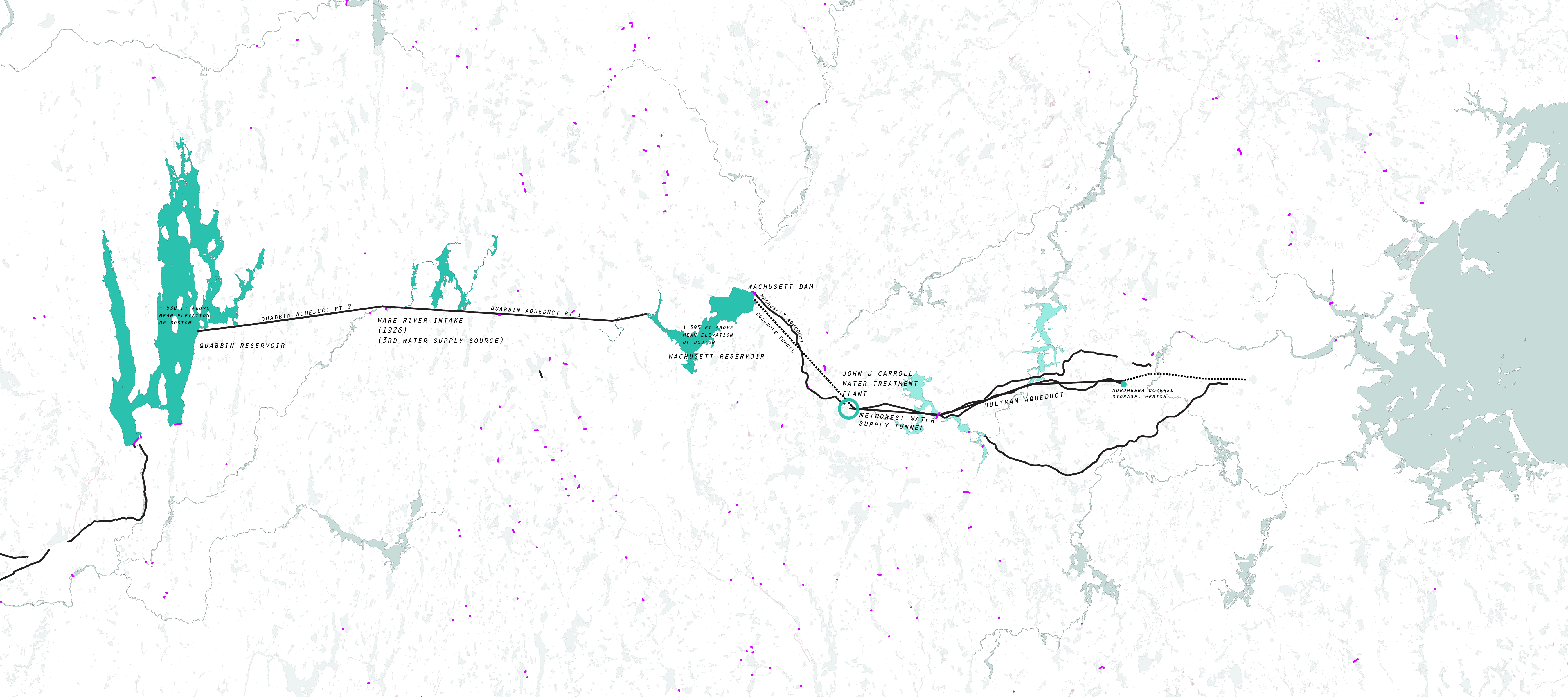
My work is focusing on explaining through mapping the paths and cataloging the infrastructure of Boston area potable water. This includes a mapping of water sources and guiding people through its paths while recognizing the extents of power and infrastructure required to make water easily accessible.

The aim is to help make people more aware of where their water comes from, the resources involved and the politics behind it in order to help them make more informed decisions and be more responsible with their water usage.
I have been speaking with other researchers who work in the field as well as people involved in the water world of Boston. Some things I have coming up coming this week, a meeting with some important people at the Metropolitan Water Resource Authority, a visit to Deer Island Treatment Plant and the MWRA museum.
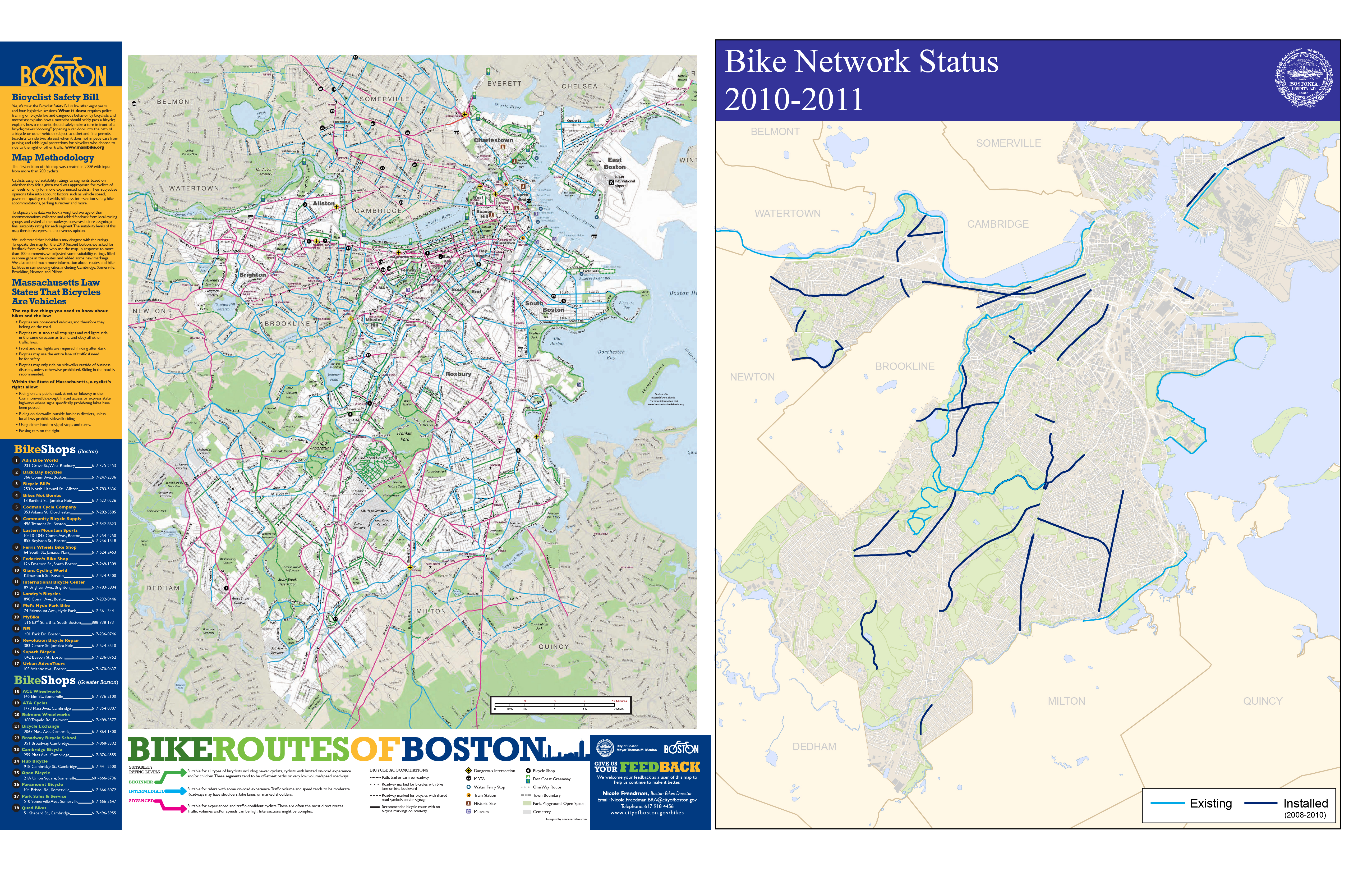
Riding a bike around the city of Boston you come to realize quite quickly that the cycle infrastructure is lacking. Even with the declaration by Mayor Menino that in Boston “the car is no longer king” and the cities recent focus on improving the cities cyclability, riding in the city is tough, scary and at times down right dangerous. The infrastructural improvements consist mostly of painted line bike lanes and Sharrows (painted bicycle arrows indicating an acceptable space within the lane a cyclist can occupy). While researching the current conditions I found that the mapping of the cycle infrastructure, and more the experience to be completely lacking. The maps of cycle lanes mainly consist of diagramatic overlays on plain google maps. I realized that there is not a map (at least I have not found one) that has the actual lanes drawn in. This type of mapping is deceiving to the rider as the system that exists is disjunct and rough with potholes and seamed pavement.
My goal first is to begin remapping the city of Boston’s cycle infrastructure to better map the experience of riding in the city. I am currently building a sensor consisting of a GPS and accelerometer to map the micro-topography in the city, additionally the speed, stops, turns and the side to side motion associated with pedaling hard will be used to redraw how open a street feels to the rider, the faster and smoother the ride, the wider the feeling of the street, the slower and more jerky the ride the narrower the feel.
From this I plan to develop an app that, though not as precise as the sensor I am constructing, has the opportunity to crowd source this data, as well as translate it back to the user, in essence creating real time crowd source mapping.
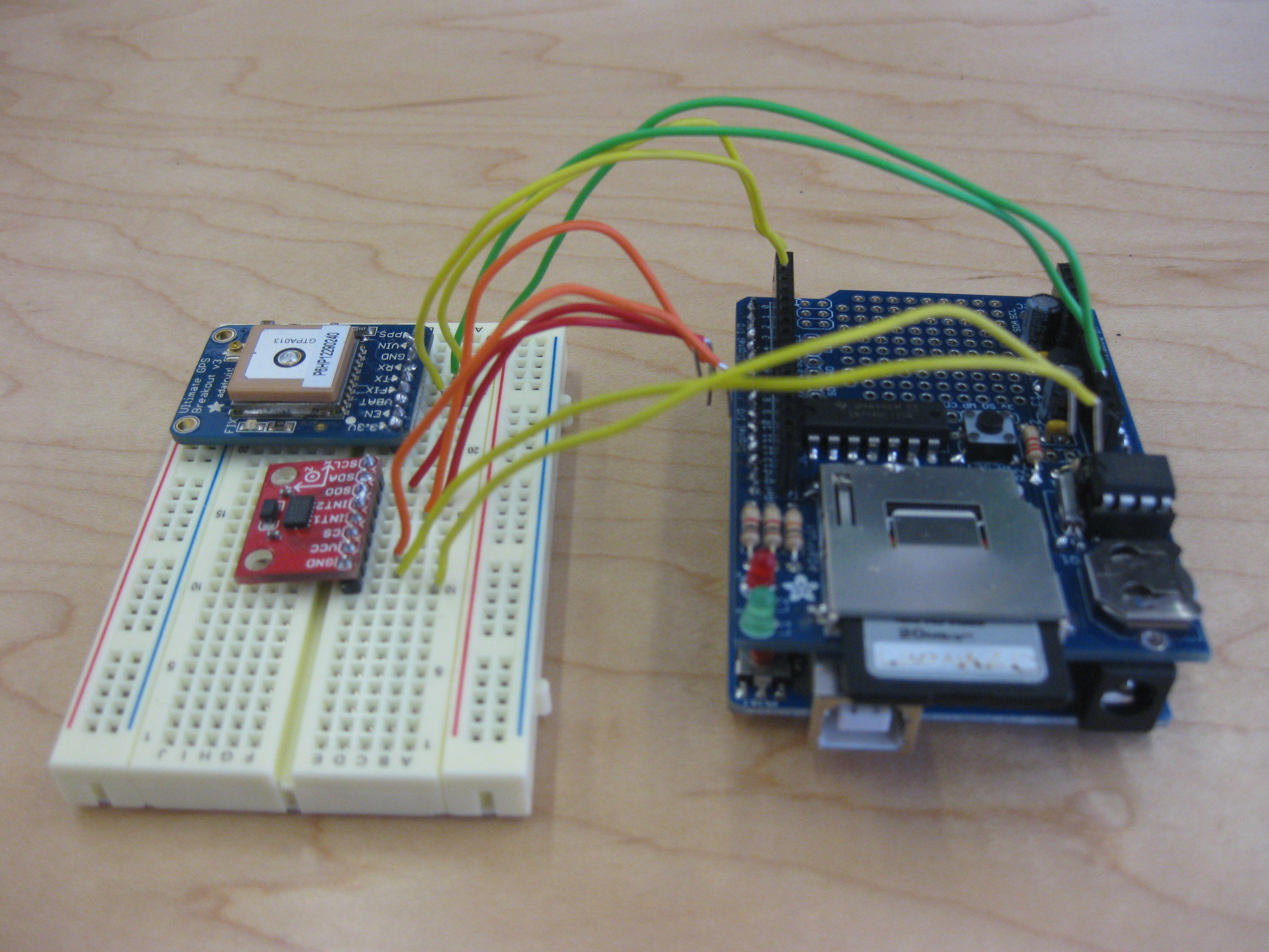
Where I Stand Now:
I am currently trying to convince all of the components of my sensor to start talking to each other. After about 15 hours yesterday I have come up with a new issue of the card not being read, hopefully that will be remedied shortly. Once that is done I just need to get the accelerometer into the party, we’ll see how that goes.
My hope for this project is that this new mapping will help to inform the urbanization and infrastructural improvements in the city.
Think Big: The cost of waste, both financial and environmental, on our cities is enormous. While the market has produced some solutions in terms of automated sorting for single stream recycling and composting farms, the largest challenge still exists at the moment of disposal. When you or I decide to throw something away where do we throw it? Do we litter? Do we properly compost or recycle? More often than not, even when we want to do the right thing we often carelessly dispose of our waste. I believe that a combination of poor design, entrenched habits, and a lack of awareness contribute to these individual behaviors. I am seeking to change what appear to be small moments in our everyday life in a way that can scale up to significantly impact our urban environments.
Start Small: My initial target is Chauhaus, the dining room at Gund Hall. After experiencing my own fits of misunderstanding every time I threw something away I began talking to other members of the GSD community and found that nearly everyone finds this setup confusing. I plan to change this through one (or more) design and behavior interventions. I am currently assessing a handful of options but plan to implement them as soon as is feasible.
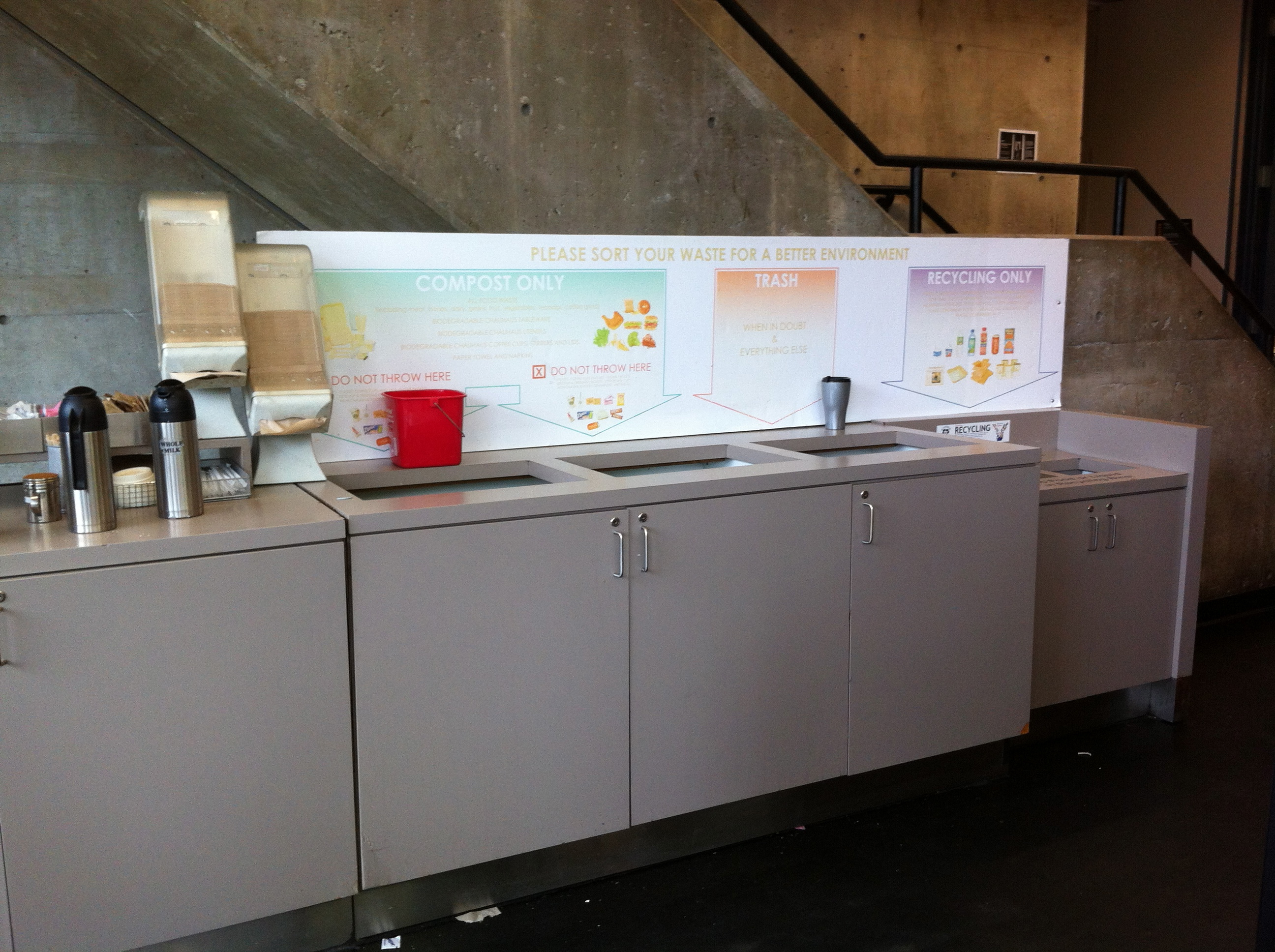
Act Now: I have met with a combination of “trash” people and “behavior” people so far, including Trevor O’Brien of GSD Building Services and Erin Frey (PhD candidate) and Professor Todd Rogers at the Kennedy School. I have a meeting scheduled for Friday morning with Rob Gogan, the department head for Recycling and Waste Services at Harvard. I have also begun filming the trash area from above during lunch times to determine the scope of the problem and establish a baseline to compare to after my intervention.
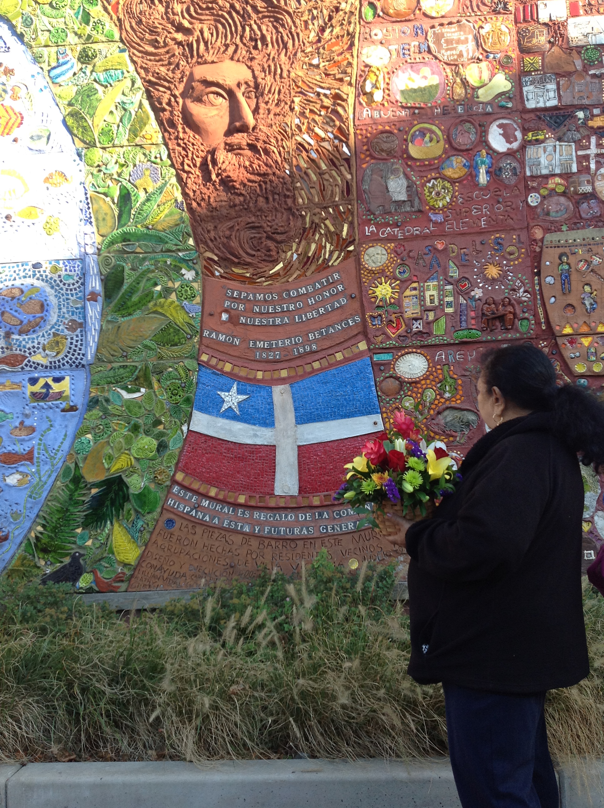 Villa Victoria community member in front of Betances Mural
This past week after my weekly visit to Villa Victoria and interviewing Anabel Vazquez-Rodriguez, curator and gallery manager in Villa Victoria Center for the Arts, two things became clear. The immigration of non-Puerto Rican groups to Villa Victoria is a recent phenomenon that still have not been mapped or deeply researched. Secondly, the existing monument of the community (Betances Mural) exclusively represents the Puerto Rican population. Today’s Villa Victoria presents a more diverse panorama with a large Chinese community, most of which speak Cantonese Anabel also mentioned that 2nd and 3rd generations of former residents have moved to the outskirts of Boston, being replaced by other cultural groups. The next step is to unveil this demographic change, and understand how it is or will affect existing community structures. Anabel also brought to my attention a documentary project on Villa Victoria ran this past summer by a grad student at MIT . I am excited to learn more about her conclusions on today’s Villa Victoria.
« Previous 1 2 3 4 5 … 7 Next »